Cadaster, Cadastral and Land information systems.
Assoc. Prof. Dr. Eng. Hristo Dechev
Faculty of Geodesy, Department Geodesy and Geoinformatics
| Office Room | R425 |
|---|---|
| Phone | +359 878 401 600 |
| hristo.m.dechev@gmail.com | |
| Marital Status | married |
Lectures
Education
Master "Geodesy", Ph.D.
Language Skills
English
Professional Skills
Data capturing and analyzing. Statistical computing methods. GIS expert, programming and database management.
Science Interests
Cadaster, geomatics, spatial data infrastructure and information systems
Participation in Research Projects
Information platform for environmental monitoring - 2018 current.
Participation in Design Projects
Revision, updating and development new roles for building cadastral maps and providing public services. Creation and implementation of an information infrastructure for web based services. Services provides information for geographical names and INSPIRE services (theme cadastral parcels).
Mapping and identification of environmental conditions and environmental habitats. Spatial coordination of the processes, taking place at the national territory through creation of spatial planning base and regulator for implementation not only the regional, but also the single socio-economic sectorial planning at national level in the context of the European spatial development for achieving a complex integrated planning
Participation in International Projects
Projects for development cadaster and property register, PHARE program, MATRA program of Netherland Cadastre, World Bank project for developing Integrated Information System for Cadastre and Property Register.
Regional Feasibility Studies (RFS) for the designated territories of the Water Supply and Sewerage companies - World Bank project.
Academic Positions
Associate Professor department "Geodesy and Geoinformatics"
Science Keywords
GIS, cadaster, spatial database
Information
резултати от изпит
Hobby
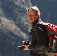
Photography and hiking

